- Alabama
- Alaska
- Arizona
- Arkansas
- California
- Colorado
- Connecticut
- Delaware
- District Of Columbia
- Florida
- Georgia
- Hawaii
- Idaho
- Illinois
- Indiana
- Iowa
- Kansas
- Kentucky
- Louisiana
- Maine
- Maryland
- Massachusetts
- Michigan
- Minnesota
- Mississippi
- Missouri
- Montana
- Nebraska
- Nevada
- New Hampshire
- New Jersey
- New Mexico
- New York
- North Carolina
- North Dakota
- Ohio
- Oklahoma
- Oregon
- Pennsylvania
- Rhode Island
- South Carolina
- South Dakota
- Tennessee
- Texas
- Utah
- Vermont
- Virginia
- Washington
- West Virginia
- Wisconsin
- Wyoming
Buoys and Markers
Buoys and markers are the "traffic signals" that guide vessel operators safely along some waterways. They also identify dangerous or controlled areas and give directions and information. Learn about the different types and colors of buoys and markers in this section.
Lateral Markers
These navigation aids mark the edges of safe water areas: for example, directing traffic within a channel. The markers use a combination of colors and numbers, which may appear on either buoys or permanently placed markers.
Red Colors, Red Lights and Even Numbers
These mark the edge of the channel on your starboard (right) side as you enter from open sea or head upstream. Numbers usually increase consecutively as you return from open sea or head upstream.
Green Colors, Green Lights and Odd Numbers
These mark the edge of the channel on your port (left) side as you enter from open sea or head upstream. Numbers usually increase consecutively as you return from open sea or head upstream.
Red and Green Colors and/or Lights
These are placed at the junction of two channels to indicate the preferred (primary) channel when a channel splits. If green is on top, the preferred channel is to the right. If red is on top, the preferred channel is to the left. These can also be referred to as "junction buoys."
Can Buoy
These cylindrical-shaped buoys are always marked with green markings and odd numbers. They mark the edge of the channel on your port (left) side when entering from open sea or heading upstream.
Daymarks
These are permanent signs attached to structures, such as posts, in the water. Common daymarks are red triangles (equivalent to nuns) and green squares (equivalent to cans). They also may be lighted.
"Red Right Returning"
In most circumstances, you can use this phrase as a reminder of the correct course when returning from open waters or heading upstream.
- Any marker displaying a yellow triangle should be passed by keeping it on the starboard (right) side of the vessel.
- Any marker displaying a yellow square should be passed by keeping it on the port (left) side of the vessel.
- These rules hold regardless of the shape or color of the channel marker or buoy on which the ICW symbols are displayed. When following the ICW, the yellow markings should be used as guides, rather than the colors and shapes of the lateral navigation markers on which they appear. Intercoastal Waterway symbols are most commonly found on daymarks.
Western Rivers System
This system of markers is used on the Mississippi River and its tributaries above Baton Rouge, Louisiana, and on some other rivers that flow toward the Gulf of Mexico. Navigation markers on the Western Rivers System are not numbered. Numbers displayed below daymarks along this system are not associated with the right or left side of the channel; these numbers indicate distance from the river's mouth (except the Ohio River, indicating distance for the headwaters).
- Give directions and information
- Warn of hazards and obstructions
- Mark controlled areas
- Mark exclusion (closed) areas
KEEP LEARNING

First Catch Center Trailer Gallery
FCC Trailer Photo Gallery
LEARN MORE
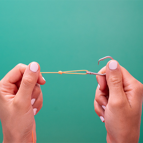
How to Tie a Duncan Knot
Learn to tie a Duncan knot by following these five simple steps. Watch our new video.
LEARN MORE

Welcome to Angler Academy!
No one said you can’t bring fishing inside! There’s lots of fun activities we can do right from home
LEARN MORE
.png?lang=en-US&ext=.png)